

By Terry Eliasen, Meteorologist, WBZ-TV Exec. Weather Producer
BOSTON – We are currently in a NEXT Weather Alert for a long-duration, multi-faceted winter storm which will arrive Sunday evening and last through Monday evening.
Much like the previous storms, this one will feature rain for some, snow for others, and changeable conditions throughout the 24+ hours of precipitation.
Perhaps the toughest call on Monday will be whether to cancel school. Most of southern New England will wake up to rain Monday morning.
But, as colder air arrives, the rain will change to a heavy, wet snow during the day Monday. This could make for treacherous travel conditions during the afternoon and evening.
Finally, we also have some concerns with wind, coastal flooding, and power outages on Monday.
While the winds won’t be nearly as strong as some of our typical nor’easters, when combined with the weight of heavy snow on the trees and power lines, there could be just enough wind to create some power outages.
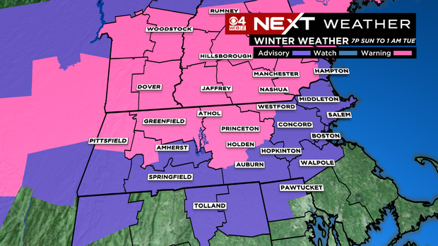
A Winter Storm Warning is in effect for the northern Worcester county and northern Middlesex county and the areas shaded in pink where the main precipitation type will likely be a heavy, wet snow. Travel could be difficult on untreated surfaces.
A Winter Weather Advisory is in effect for the city of Boston and the areas shaded in purple. Lesser amounts of snow are expected, but plan on slippery road conditions, especially midday Monday and into the Monday evening commute.
CBS Boston Graphic
TIMELINE
A rain/snow mix will continue Sunday night across the Bay State with colder conditions mainly north of the Pike leading to snow, while milder conditions to the southeast leading to rain.
Within a few hours, before midnight, enough mild air will work in to push the rain/snow line northward closer to New Hampshire. The only areas in southern New England that will see any snow overnight are the Berkshires and perhaps, at times, the northern Worcester Hills. Essentially, for the rest of the area, this will just be a rainy night.
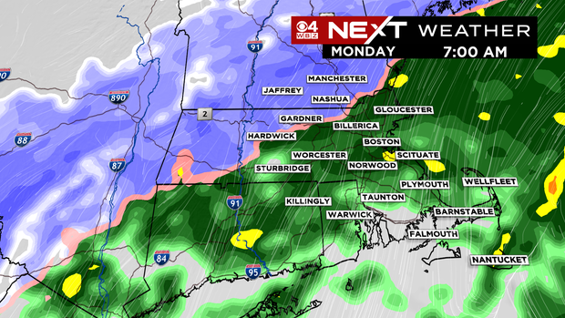
When you wake up Monday morning, same deal – raining just about everywhere, perhaps some wet snow mixing in at the highest elevations in northern Worcester County.
CBS Boston Graphic
This will make for a very tough decision for schools. Do you close based upon the forecast for a change to snow? I think it depends largely upon a few key factors.
What time will the change occur? How much snow do we expect to accumulate on Monday? Finally, what is the risk of power outages? Let’s see if we can answer some of those questions.
Approximate changeover from rain to snow on Monday:
10 a.m.: Northern Worcester County, northwest Middlesex County (Towns such as: Fitchburg, Nashua, Townsend).
Noon: Northwestern parts of Interstate 495: (Towns such as: Lowell, Lawrence, Amesbury), essentially all of northern Massachusetts and southern New Hampshire.
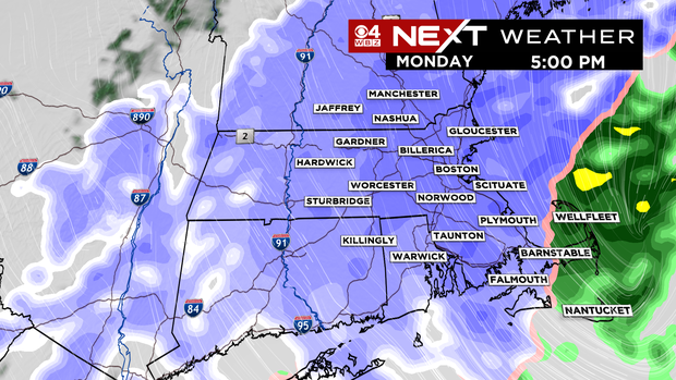
2 p.m.: By this time it will be snowing in all areas along and north of the Mass PIke including Worcester and Boston. Also expect the snow to have reached all of Norfolk County and northern parts of Bristol and Plymouth counties.
4 p.m.: Snowing in all of southern New England outside of the Outer Cape and Nantucket.
CBS Boston Graphic
Thankfully, the snow will begin to taper off in the evening from west to east. It should end in parts of central Mass. around 6-8 p.m. and in eastern Mass. between 8-10 p.m.
HOW MUCH?
The snow amounts are not an easy call. Much like the last storm, the temperatures will be very close to 32 degrees for a large part of the lower atmosphere and surface temperatures in many areas will be slightly above freezing Monday afternoon while it is snowing. So, it will take a fairly heavy rate to get any sort of significant accumulation. It does appear as though it will snow long enough and heavy enough for some accumulation to occur in eastern Mass. Monday afternoon and evening.
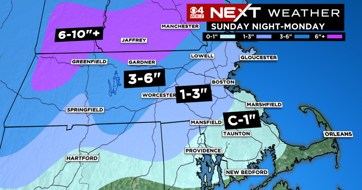
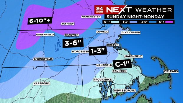
Forecast amounts:
Coating to 1 inch: Down by the South Coast and South Shore (all coming later on Monday). We need to watch this area closely, as a burst of snow in the afternoon may lead up to a couple of inches on unpaved surfaces.
1 to 3 inches: Mainly East of I-495 to the north shore to Boston and parts of interior Southeastern Mass. (All coming Monday afternoon and evening).
3 to 6 inches: Around and West of I-495 From northern Essex County into northwestern Middlesex County and a majority of Worcester County into New Hampshire and as far south as northern CT. (mostly coming Monday midday through evening).
6 to 10 inches+: Northern Worcester County, the Berkshires and southwest New Hampshire. The 10+ would only be in the highest elevations where precipitation stays all snow (storm total, some overnight, some during Monday).
CBS Boston Graphic
OTHER IMPACTS
We do have an added wind concern with this storm unlike the last few. We expect north-northeast gusts between 20-40 MPH during Monday morning/midday.
Then, as the storm starts to wrap up and exit, the winds will shift to the north-northwest, gusting 20-40 MPH during Monday afternoon and evening.
Again, combined with a very heavy, wet snowfall, this could be just enough wind to cause some downed limbs and power lines.
Also, given that our tides are astronomically high on Monday, there will likely be some minor coastal flooding during the midday high tide cycle. The typically vulnerable shore roads may briefly be washed out.
WHAT’S NEXT
No rest for the weary! There is another storm headed our way later on Wednesday!
This one looks like it may start snow Wednesday evening and change to rain overnight, lasting well into Thursday.
Busy week in the weather office. More on that storm to come.
Follow Terry on Twitter @TerryWBZ